Loading content...
USA Time Zone Map with States & Current Time Zones
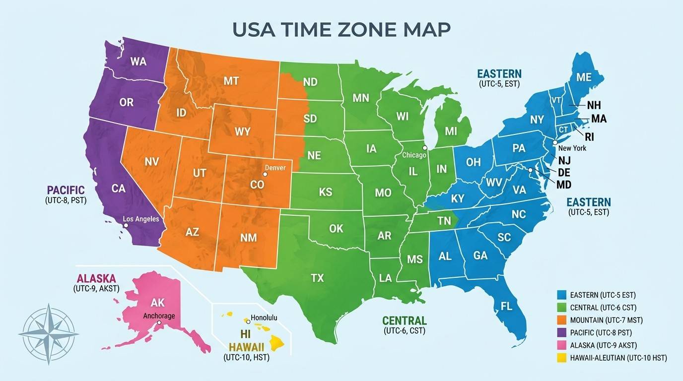
The USA Time Zone Map helps you understand how time is divided across the United States. It shows the six official U.S. time zones, state boundaries, UTC offsets, and areas that follow Daylight Saving Time (DST). Whether you're planning a trip, scheduling an online meeting, studying geography, or looking for a printable map, this guide provides everything you need in one place.
The United States covers a large area from the Atlantic Ocean to the Pacific Ocean and includes Alaska, Hawaii, and several U.S. territories. Because of this wide distance, one standard time would not work across the country. Instead, the U.S. uses multiple time zones so that local time matches the position of the sun in different regions.
On this page, you'll find a USA Time Zone Map with states, detailed explanations of all six official time zones, state-wise time zone information, UTC offsets, Daylight Saving Time rules, printable maps, and answers to common questions. By the end of this guide, you'll have a clear understanding of how time works across the United States.
Download USA Time Zone Map
If you're looking for a map you can save or print, this page includes several useful versions of the Printable USA Time Zone Map.
You can use these maps for:
- Classroom projects
- Geography lessons
- Travel planning
- Business scheduling
- Office presentations
- School assignments
- Remote work
- Flight planning
- Road trips
- Personal reference
Available download options include:
- Printable USA Time Zone Map PDF
- High-Resolution PNG
- Labeled USA Time Zone Map
- Blank USA Time Zone Map
- Black and White Time Zone Map
- Color Time Zone Map
These maps make it easy to compare time differences between states and understand where each time zone begins and ends.
USA Time Zone Map at a Glance
Here is a quick overview of the official time zones used in the United States.
| Time Zone | Standard Time (UTC) | Daylight Saving Time | Major Cities |
|---|---|---|---|
| Eastern Time (ET) | UTC−5 | UTC−4 | New York, Miami, Atlanta, Washington D.C. |
| Central Time (CT) | UTC−6 | UTC−5 | Chicago, Dallas, Houston, New Orleans |
| Mountain Time (MT) | UTC−7 | UTC−6 | Denver, Salt Lake City, Albuquerque |
| Pacific Time (PT) | UTC−8 | UTC−7 | Los Angeles, San Francisco, Seattle, Las Vegas |
| Alaska Time (AKT) | UTC−9 | UTC−8 | Anchorage, Juneau |
| Hawaii-Aleutian Time (HAT) | UTC−10 | No DST in Hawaii | Honolulu |
What Is the USA Time Zone Map?
A USA Time Zone Map is a map that shows how the United States is divided into different time zones. Each color or section on the map represents a specific time zone used by states, counties, and major cities.
Instead of using one clock for the entire country, the United States follows different local times based on geographic location. This system allows people in different regions to experience daylight during normal working hours.
For example:
- When it is 9:00 AM in New York, it is 8:00 AM in Chicago.
- At the same moment, it is 7:00 AM in Denver.
- In Los Angeles, the local time is 6:00 AM.
- In Honolulu, it is 3:00 AM.
Without separate time zones, sunrise and sunset would happen at unusual hours in many parts of the country.
Why Does the USA Have Multiple Time Zones?
One of the most common questions people ask is:
"Why does the United States have six time zones?"
The answer is simple—the country is very large.
The United States stretches across thousands of miles from east to west. Because the Earth rotates, the sun rises earlier in eastern states than in western states. If every state followed the same clock, daily life would become confusing.
Imagine using New York's time in California. During part of the year, the sun would not rise until after 10:00 AM in some places. Schools, offices, airports, and businesses would all face scheduling problems.
To solve this issue, the country follows multiple standard time zones.
Today, the official U.S. time zones help millions of people coordinate:
- Flights
- Train schedules
- Television broadcasts
- Business meetings
- Stock market hours
- Government offices
- Online events
- Remote work
- Emergency services
This standardized system keeps daily life organized across the country.
How Many Time Zones Are There in the USA?
Most people know about four U.S. time zones, but there are actually six official time zones used across the 50 states.
These include:
- Eastern Time (ET)
- Central Time (CT)
- Mountain Time (MT)
- Pacific Time (PT)
- Alaska Time (AKT)
- Hawaii-Aleutian Time (HAT)
In addition to these, several U.S. territories use their own local time zones, which are different from those of the mainland United States.
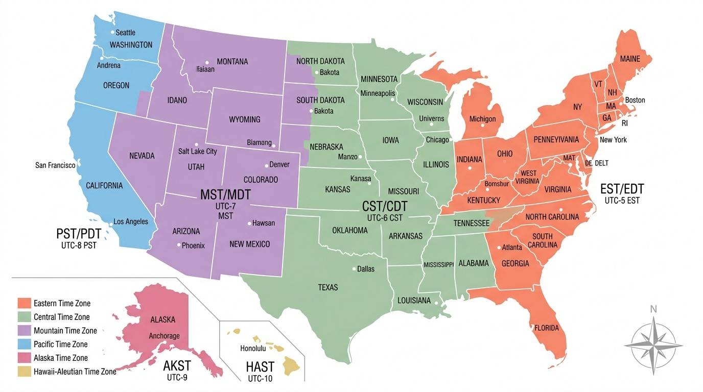
Understanding the Six Official U.S. Time Zones
Each time zone follows its own local clock and UTC offset. Here's a closer look at each one.
Eastern Time Zone (ET)
The Eastern Time Zone is the most populous time zone in the United States. It covers much of the East Coast and is home to many of the country's largest cities, financial centers, and government offices.
Standard Time
UTC−5
Daylight Saving Time
UTC−4
Major Cities
- New York City
- Washington, D.C.
- Philadelphia
- Boston
- Atlanta
- Miami
- Orlando
- Charlotte
States Using Eastern Time
Examples include:
- New York
- New Jersey
- Pennsylvania
- Massachusetts
- Connecticut
- Delaware
- Maryland
- Virginia
- South Carolina
- Georgia
- Most of Florida
- Ohio
- Michigan (most areas)
The Eastern Time Zone is widely used by financial markets, national news networks, and federal government offices.
Central Time Zone (CT)
The Central Time Zone covers much of the central United States. It includes many farming regions, industrial cities, and major transportation hubs.
Standard Time
UTC−6
Daylight Saving Time
UTC−5
Major Cities
- Chicago
- Dallas
- Houston
- Austin
- San Antonio
- Minneapolis
- Memphis
- New Orleans
- Kansas City
States Using Central Time
Some examples are:
- Texas (most areas)
- Illinois
- Alabama
- Mississippi
- Louisiana
- Wisconsin
- Iowa
- Minnesota
- Missouri
- Arkansas
- Oklahoma
Several states, including Texas, Kansas, Nebraska, South Dakota, North Dakota, Kentucky, Tennessee, and Florida, have regions that use more than one time zone. We'll cover these in detail later in this guide.
Mountain Time Zone (MT)
The Mountain Time Zone is used across parts of the Rocky Mountain region and several western states. It covers areas known for national parks, mountain ranges, and outdoor recreation.
Standard Time
UTC−7
Daylight Saving Time
UTC−6
Major Cities
- Denver
- Salt Lake City
- Albuquerque
- Boise (southern Idaho)
- Colorado Springs
States Using Mountain Time
Examples include:
- Colorado
- Utah
- Montana
- Wyoming
- New Mexico
- Arizona (with special DST rules)
- Southern Idaho
Mountain Time is one hour behind Central Time and one hour ahead of Pacific Time.
Pacific Time Zone (PT)
The Pacific Time Zone (PT) covers the western coast of the United States. It is home to famous cities, technology companies, entertainment industries, and some of the country's busiest ports. If you've ever watched a TV schedule that mentions "8 PM ET / 5 PM PT," this is the time zone being referenced.
Standard Time
UTC−8
Daylight Saving Time
UTC−7
Major Cities
- Los Angeles
- San Francisco
- San Diego
- Sacramento
- Seattle
- Portland (most areas)
- Las Vegas
States Using Pacific Time
The Pacific Time Zone is used in:
- California
- Washington
- Most of Oregon
- Part of Nevada
Millions of people living on the West Coast use Pacific Time every day for work, travel, entertainment, and business.
Alaska Time Zone (AKT)
The Alaska Time Zone is used across most of the state of Alaska. Since Alaska is located far northwest of the mainland United States, it follows its own official time zone.
Standard Time
UTC−9
Daylight Saving Time
UTC−8
Major Cities
- Anchorage
- Fairbanks
- Juneau
- Sitka
Although Alaska is very large, most residents use the same time zone. This makes communication and transportation easier throughout the state.
Hawaii-Aleutian Time Zone (HAT)
The Hawaii-Aleutian Time Zone is used in Hawaii and parts of Alaska's Aleutian Islands.
Standard Time
UTC−10
Daylight Saving Time
Hawaii does not observe Daylight Saving Time. Clocks remain the same throughout the year.
Major City
- Honolulu
Because Hawaii is close to the equator, daylight hours remain fairly consistent during the year. This is one reason the state does not participate in DST.
USA Time Zones by State
One of the most common questions people ask is:
"Which time zone does my state use?"
The table below shows the official time zone used by every U.S. state, along with whether it observes Daylight Saving Time.
| State | Primary Time Zone | DST |
|---|---|---|
| Alabama | Central | Yes |
| Alaska | Alaska | Yes |
| Arizona | Mountain | Most areas No |
| Arkansas | Central | Yes |
| California | Pacific | Yes |
| Colorado | Mountain | Yes |
| Connecticut | Eastern | Yes |
| Delaware | Eastern | Yes |
| Florida | Eastern & Central | Yes |
| Georgia | Eastern | Yes |
| Hawaii | Hawaii-Aleutian | No |
| Idaho | Mountain & Pacific | Yes |
| Illinois | Central | Yes |
| Indiana | Eastern | Yes |
| Iowa | Central | Yes |
| Kansas | Central & Mountain | Yes |
| Kentucky | Eastern & Central | Yes |
| Louisiana | Central | Yes |
| Maine | Eastern | Yes |
| Maryland | Eastern | Yes |
| Massachusetts | Eastern | Yes |
| Michigan | Eastern | Yes |
| Minnesota | Central | Yes |
| Mississippi | Central | Yes |
| Missouri | Central | Yes |
| Montana | Mountain | Yes |
| Nebraska | Central & Mountain | Yes |
| Nevada | Pacific | Yes |
| New Hampshire | Eastern | Yes |
| New Jersey | Eastern | Yes |
| New Mexico | Mountain | Yes |
| New York | Eastern | Yes |
| North Carolina | Eastern | Yes |
| North Dakota | Central & Mountain | Yes |
| Ohio | Eastern | Yes |
| Oklahoma | Central | Yes |
| Oregon | Pacific & Mountain | Yes |
| Pennsylvania | Eastern | Yes |
| Rhode Island | Eastern | Yes |
| South Carolina | Eastern | Yes |
| South Dakota | Central & Mountain | Yes |
| Tennessee | Eastern & Central | Yes |
| Texas | Central & Mountain | Yes |
| Utah | Mountain | Yes |
| Vermont | Eastern | Yes |
| Virginia | Eastern | Yes |
| Washington | Pacific | Yes |
| West Virginia | Eastern | Yes |
| Wisconsin | Central | Yes |
| Wyoming | Mountain | Yes |
States That Have More Than One Time Zone
Not every U.S. state follows a single time zone. Some states are divided into two different time zones because of their size, geography, or economic connections with neighboring states.
Here are the states with multiple time zones.
Florida
Most of Florida follows Eastern Time, while the western part of the Florida Panhandle follows Central Time.
Texas
Texas is mainly in the Central Time Zone. However, El Paso and Hudspeth County use Mountain Time.
Tennessee
The eastern part of Tennessee follows Eastern Time, while central and western Tennessee use Central Time.
Kentucky
Kentucky is divided between the Eastern and Central time zones.
Kansas
Most of Kansas follows Central Time, but several western counties observe Mountain Time.
Nebraska
Most of Nebraska uses Central Time, while western Nebraska uses Mountain Time.
North Dakota
North Dakota follows both Central and Mountain Time.
South Dakota
Eastern South Dakota uses Central Time, while western South Dakota follows Mountain Time.
Idaho
Most of Idaho observes Mountain Time, but the northern part of the state uses Pacific Time.
Oregon
Most of Oregon follows Pacific Time, while the southeastern corner observes Mountain Time.
Indiana
Indiana previously had multiple time zone rules and DST policies. Today, most of the state follows Eastern Time, while a few counties near Chicago and Evansville observe Central Time.
Michigan
Most of Michigan uses Eastern Time, while a small portion of the Upper Peninsula near Wisconsin follows Central Time.
USA Time Zones by Major Cities
Many users search for the time zone of a specific city instead of a state. Here's a quick reference table for some of the most popular U.S. cities.
| City | State | Time Zone |
|---|---|---|
| New York City | New York | Eastern |
| Washington, D.C. | District of Columbia | Eastern |
| Boston | Massachusetts | Eastern |
| Miami | Florida | Eastern |
| Orlando | Florida | Eastern |
| Atlanta | Georgia | Eastern |
| Charlotte | North Carolina | Eastern |
| Chicago | Illinois | Central |
| Dallas | Texas | Central |
| Houston | Texas | Central |
| Austin | Texas | Central |
| San Antonio | Texas | Central |
| Minneapolis | Minnesota | Central |
| New Orleans | Louisiana | Central |
| Denver | Colorado | Mountain |
| Salt Lake City | Utah | Mountain |
| Albuquerque | New Mexico | Mountain |
| Phoenix | Arizona | Mountain (No DST) |
| Los Angeles | California | Pacific |
| San Francisco | California | Pacific |
| San Diego | California | Pacific |
| Seattle | Washington | Pacific |
| Portland | Oregon | Pacific |
| Las Vegas | Nevada | Pacific |
| Anchorage | Alaska | Alaska |
| Honolulu | Hawaii | Hawaii-Aleutian |
Time Difference Between U.S. Time Zones
If you're planning a meeting or trip, knowing the time difference between major regions is essential.
| From | To | Time Difference |
|---|---|---|
| Eastern → Central | 1 hour behind | |
| Eastern → Mountain | 2 hours behind | |
| Eastern → Pacific | 3 hours behind | |
| Eastern → Alaska | 4 hours behind | |
| Eastern → Hawaii | 5 hours behind | |
| Central → Pacific | 2 hours behind | |
| Mountain → Pacific | 1 hour behind | |
| Pacific → Hawaii | 2 hours behind | |
| Alaska → Hawaii | 1 hour behind |
Example
If it's:
- 9:00 AM in New York
- 8:00 AM in Chicago
- 7:00 AM in Denver
- 6:00 AM in Los Angeles
- 5:00 AM in Anchorage
- 4:00 AM in Honolulu
Understanding these differences helps when scheduling business meetings, booking flights, joining online classes, or calling friends and family across the country.
USA Time Zone Boundaries
The borders between time zones do not always follow state lines. Instead, they often follow county boundaries, rivers, highways, or local administrative decisions.
For example:
- Florida is split between Eastern and Central Time.
- Idaho uses both Pacific and Mountain Time.
- Oregon has areas in both Pacific and Mountain Time.
- Texas includes both Central and Mountain Time.
- Nebraska, Kansas, and the Dakotas also have divided time zones.
These boundaries were designed to keep nearby communities, businesses, and transportation systems operating on the most practical local time.
Daylight Saving Time (DST) in the USA
Daylight Saving Time (DST) is the practice of moving clocks forward by one hour during the warmer months of the year. The goal is to make better use of natural daylight in the evening.
Instead of changing the length of the day, DST simply shifts the clock by one hour. This means people can enjoy more daylight after work or school while reducing the need for artificial lighting.
Most states in the United States follow Daylight Saving Time. However, there are a few important exceptions.
When Does Daylight Saving Time Start?
In most parts of the United States, Daylight Saving Time begins on the second Sunday in March.
At 2:00 AM local time, clocks move forward by one hour. For example, when the clock reaches 2:00 AM, it immediately changes to 3:00 AM.
This is often called "Spring Forward."
When Does Daylight Saving Time End?
Daylight Saving Time ends on the first Sunday in November.
At 2:00 AM, clocks move back by one hour, returning to standard time.
This is known as "Fall Back."
Because of this change, people gain one extra hour of sleep on the day DST ends.
Which States Do Not Observe DST?
Although most of the country follows Daylight Saving Time, there are important exceptions.
Hawaii
The entire state of Hawaii stays on the same time throughout the year. Since sunrise and sunset times change very little near the equator, DST offers little benefit.
Arizona
Most of Arizona does not observe Daylight Saving Time.
The exception is the Navajo Nation, which follows DST because it spans several states.
Time Zones During Daylight Saving Time
When DST begins, UTC offsets change by one hour.
| Time Zone | Standard Time | During DST |
|---|---|---|
| Eastern Time | UTC−5 | UTC−4 |
| Central Time | UTC−6 | UTC−5 |
| Mountain Time | UTC−7 | UTC−6 |
| Pacific Time | UTC−8 | UTC−7 |
| Alaska Time | UTC−9 | UTC−8 |
| Hawaii-Aleutian Time | UTC−10 | No Change |
Understanding these changes is important for international meetings, travel, flight schedules, and online events.
What Is UTC?
UTC (Coordinated Universal Time) is the global time standard used around the world.
Every time zone is measured by how many hours it is ahead of or behind UTC.
For example:
- Eastern Standard Time = UTC−5
- Central Standard Time = UTC−6
- Mountain Standard Time = UTC−7
- Pacific Standard Time = UTC−8
UTC does not change for Daylight Saving Time, making it the standard reference for aviation, shipping, satellite systems, weather forecasting, and computer networks.
Complete USA UTC Offset Chart
The table below shows the UTC offsets used by each official U.S. time zone.
| Time Zone | Standard Time | Daylight Saving Time |
|---|---|---|
| Eastern (ET) | UTC−5 | UTC−4 |
| Central (CT) | UTC−6 | UTC−5 |
| Mountain (MT) | UTC−7 | UTC−6 |
| Pacific (PT) | UTC−8 | UTC−7 |
| Alaska (AKT) | UTC−9 | UTC−8 |
| Hawaii-Aleutian (HAT) | UTC−10 | No DST |
This chart is especially useful for remote workers, software developers, international businesses, and travelers.
U.S. Territories and Their Time Zones
Many people focus only on the 50 states, but the United States also has several territories with their own official time zones.
| U.S. Territory | Time Zone |
|---|---|
| Puerto Rico | Atlantic Standard Time (UTC−4) |
| U.S. Virgin Islands | Atlantic Standard Time (UTC−4) |
| Guam | Chamorro Standard Time (UTC+10) |
| Northern Mariana Islands | Chamorro Standard Time (UTC+10) |
| American Samoa | Samoa Standard Time (UTC−11) |
| Wake Island | Wake Island Time (UTC+12) |
These territories are important for government operations, military activities, tourism, and international communication.
Printable USA Time Zone Map
A Printable USA Time Zone Map is useful for anyone who needs a physical copy for reference.
Many users prefer printable maps because they can be used without an internet connection.
Popular download formats include:
- Printable PDF
- High-Resolution PNG
- JPG Image
- SVG File
- Letter Size Print
- A4 Print
- Poster Size
Printable maps are commonly used by:
- Teachers
- Students
- Travelers
- Businesses
- Delivery companies
- Truck drivers
- Event planners
Blank USA Time Zone Map
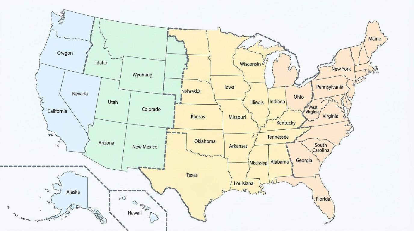
A Blank USA Time Zone Map does not include labels or colors.
This version is commonly used for:
- Geography practice
- School assignments
- Classroom quizzes
- Educational worksheets
- Map labeling exercises
- Homeschool activities
Students can use the blank map to identify different time zones and practice locating state boundaries.
Labeled USA Time Zone Map
A Labeled USA Time Zone Map displays the names of each official time zone along with state boundaries.
This version is ideal for:
- Learning geography
- Travel planning
- Classroom presentations
- Business reference
- Research projects
Since all time zones are clearly marked, it is the easiest version for beginners to understand.
Color-Coded USA Time Zone Map
Many maps use different colors to separate each time zone.
For example:
- Blue for Eastern Time
- Green for Central Time
- Orange for Mountain Time
- Red for Pacific Time
- Purple for Alaska Time
- Yellow for Hawaii Time
Color coding makes it easier to recognize time zone boundaries at a glance.
How to Read a USA Time Zone Map
Reading a U.S. Time Zone Map is simple once you understand the basics.
Follow these steps:
- Locate your state on the map.
- Identify the color or label representing its time zone.
- Check the UTC offset if you need to compare times with another country.
- See whether the state follows Daylight Saving Time.
- If your state has multiple time zones, check the county or regional boundary.
Using these five steps, you can quickly determine the correct local time anywhere in the United States.
Uses of a USA Time Zone Map
A United States Time Zone Map is more than just a geography tool. It has practical uses in everyday life.
Travel Planning
Travelers use the map to calculate arrival times, avoid confusion during road trips, and prepare for time changes between states.
Flight Scheduling
Airlines publish departure and arrival times based on local time. A time zone map helps passengers understand the actual travel duration.
Business Meetings
Companies with offices in different states rely on time zone maps to schedule meetings without conflicts.
Remote Work
Remote employees often collaborate with teammates across several time zones. Knowing the time difference helps avoid missed meetings.
Online Classes
Students attending virtual classes from different states can convert class schedules accurately.
Logistics and Shipping
Delivery companies use time zone information to estimate shipping times and coordinate nationwide operations.
Broadcasting
Television networks announce programs using multiple time zones, such as 8 PM ET / 7 PM CT.
Emergency Services
Government agencies, weather departments, and emergency responders use standardized time to coordinate operations across regions.
Interesting Facts About USA Time Zones
The United States has one of the world's largest and most complex time zone systems. Here are some interesting facts that many people don't know.
1. The United States Has Six Official Time Zones
The 50 U.S. states use six official time zones:
- Eastern Time (ET)
- Central Time (CT)
- Mountain Time (MT)
- Pacific Time (PT)
- Alaska Time (AKT)
- Hawaii-Aleutian Time (HAT)
Several U.S. territories use additional time zones.
2. Time Zones Were Standardized in 1883
Before standard time was introduced, every town set its own local time based on the sun. This created confusion for railroads and travelers.
To solve this problem, North American railroads introduced standardized time zones on November 18, 1883, often called "The Day of Two Noons."
3. Hawaii Does Not Observe Daylight Saving Time
Unlike most U.S. states, Hawaii keeps the same time throughout the year because daylight hours remain fairly consistent.
4. Most of Arizona Does Not Change Its Clocks
Arizona stays on Mountain Standard Time year-round, except for the Navajo Nation, which follows Daylight Saving Time.
5. Some States Have More Than One Time Zone
States such as Florida, Texas, Oregon, Idaho, Kentucky, Tennessee, Nebraska, Kansas, North Dakota, South Dakota, Indiana, and Michigan are divided into two time zones.
6. Alaska Is the Largest U.S. State
Although Alaska spans a vast geographic area, almost the entire state uses one primary time zone, making travel and communication simpler.
7. Time Zone Boundaries Follow Counties
Many time zone borders follow county lines rather than state borders. This helps neighboring communities stay on the same schedule for work, schools, and transportation.
8. The U.S. Territories Use Different Time Zones
Territories such as Puerto Rico, Guam, American Samoa, and the U.S. Virgin Islands each follow their own official local time.
9. Airlines Always Use Local Time
Flight departure and arrival times are shown in the local time of each airport. A time zone map helps travelers avoid confusion.
10. Time Zones Affect Daily Life
From stock markets and television broadcasts to online meetings and weather alerts, time zones play an important role in everyday life across the United States.
Common U.S. Time Zone Abbreviations
Understanding time zone abbreviations makes it easier to read travel schedules, event invitations, and business meetings.
| Abbreviation | Full Name |
|---|---|
| EST | Eastern Standard Time |
| EDT | Eastern Daylight Time |
| CST | Central Standard Time |
| CDT | Central Daylight Time |
| MST | Mountain Standard Time |
| MDT | Mountain Daylight Time |
| PST | Pacific Standard Time |
| PDT | Pacific Daylight Time |
| AKST | Alaska Standard Time |
| AKDT | Alaska Daylight Time |
| HST | Hawaii Standard Time |
| UTC | Coordinated Universal Time |
| GMT | Greenwich Mean Time |
Frequently Asked Questions (FAQs)
Q. What are the six time zones in the United States?
The six official U.S. time zones are Eastern, Central, Mountain, Pacific, Alaska, and Hawaii-Aleutian. Each time zone follows a different UTC offset to match local daylight hours.
Q. Which U.S. state has two time zones?
Several states have two time zones, including Florida, Texas, Oregon, Idaho, Kansas, Nebraska, Kentucky, Tennessee, North Dakota, South Dakota, Indiana, and Michigan.
Q. What time zone is New York in?
New York follows the Eastern Time Zone (ET). It uses Eastern Standard Time (UTC−5) and Eastern Daylight Time (UTC−4) during Daylight Saving Time.
Q. What time zone is California in?
California uses the Pacific Time Zone (PT). During standard time, it follows UTC−8, and during Daylight Saving Time, it follows UTC−7.
Q. Does Texas have more than one time zone?
Yes. Most of Texas uses Central Time, while El Paso and Hudspeth County observe Mountain Time.
Q. Does Florida have two time zones?
Yes. Most of Florida follows Eastern Time, while the western part of the Florida Panhandle follows Central Time.
Q. Does Arizona observe Daylight Saving Time?
Most of Arizona does not observe Daylight Saving Time. The main exception is the Navajo Nation, which follows DST.
Q. Does Hawaii observe Daylight Saving Time?
No. Hawaii remains on Hawaii Standard Time (HST) throughout the year and does not change its clocks.
Q. Why does the United States have multiple time zones?
The United States spans thousands of miles from east to west. Multiple time zones ensure that sunrise, sunset, work hours, and daily activities stay aligned with local daylight.
Q. What is the difference between EST and EDT?
EST (Eastern Standard Time) is used during standard time (UTC−5), while EDT (Eastern Daylight Time) is used during Daylight Saving Time (UTC−4).
Q. What is UTC?
UTC (Coordinated Universal Time) is the international standard for measuring time. Every U.S. time zone is based on its difference from UTC.
Q. Can I download a printable USA Time Zone Map?
Yes. Many websites provide printable USA Time Zone Maps in PDF, PNG, SVG, and other formats for education, travel, and business use.
Q. Which U.S. states do not observe Daylight Saving Time?
Hawaii and most of Arizona do not observe Daylight Saving Time.
Q. What is the earliest time zone in the United States?
Among the 50 states, the Eastern Time Zone is the earliest. However, some U.S. territories use time zones that are ahead of the mainland.
Q. Which U.S. territory is farthest ahead in time?
Wake Island uses UTC+12, making it one of the farthest-ahead U.S. territories.
Q. How many official time zones are there in the USA?
The 50 U.S. states use six official time zones, while additional time zones are used by U.S. territories.
Q. What is the best USA Time Zone Map for travel?
A labeled, high-resolution USA Time Zone Map with state boundaries and major cities is the best choice for travelers because it clearly shows time differences across the country.
Conclusion
The USA Time Zone Map is an essential resource for understanding how time is organized across the United States. Whether you're checking the time in another state, planning a trip, scheduling a business meeting, or studying U.S. geography, a clear time zone map makes it easy to compare local times and avoid confusion.
This guide covers all six official U.S. time zones, explains Daylight Saving Time, lists time zones by state and major city, provides UTC offsets, highlights states with multiple time zones, and includes information about U.S. territories. You can also use the printable and labeled maps for school projects, travel planning, office work, or everyday reference.
As time differences affect communication, transportation, and business across the country, keeping a reliable United States Time Zone Map handy can help you plan more efficiently and stay on schedule wherever you are.

Jacqueline Y.
New Jersey, USA
I'm Jacqueline, a creator from New Jersey who enjoys simplifying geography, mapping concepts, and community learning. This article helps students, teachers, travelers, and explorers understand local maps easily.
Latest Maps
View All →