Loading content...
USA Road Map - Explore Highways, Routes & Travel Guide
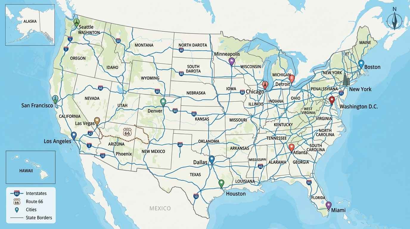
Planning a road trip across the United States? Whether you're driving along the Pacific Coast, exploring the deserts of Arizona, or traveling from New York to Florida, having a detailed USA Road Map makes your journey easier and more enjoyable. A road map not only helps you find the best routes but also gives you a better understanding of how the country's highways, cities, and scenic roads are connected.
The United States is home to one of the largest road networks in the world. Thousands of miles of interstate highways, U.S. highways, state roads, and local routes connect every state, making it possible to travel almost anywhere by car. From busy metropolitan areas to peaceful countryside roads, a reliable United States Road Map helps you plan your trip with confidence.
Although GPS apps are widely used today, many travelers still prefer using a USA Highway Map when planning long-distance journeys. A road map provides a complete overview of your route, making it easier to compare different paths, estimate travel distances, and discover interesting places along the way. It also serves as a reliable backup in areas where mobile signals are weak or unavailable.
Whether you're planning a family vacation, a weekend getaway, a business trip, or a cross-country adventure, this guide will help you understand the American road system and choose the best routes for your journey.
USA Road Map Overview
A USA Road Map is much more than a navigation tool. It shows how major highways, interstate routes, state roads, and local streets connect cities, towns, national parks, and tourist attractions across the country.
The U.S. road network has been developed over many decades and is designed to support millions of travelers every day. Whether you're visiting famous landmarks, national parks, or hidden small towns, a detailed road map helps you travel safely and efficiently.
What Does a USA Road Map Show?
A modern road map includes a wide range of useful information, such as:
- Interstate highways
- U.S. highways
- State highways
- Major cities and towns
- State boundaries
- National parks and forests
- Rivers and lakes
- Airports
- Scenic byways
- Rest areas
- Tourist attractions
This information helps travelers understand the bigger picture instead of simply following turn-by-turn directions.
Types of Roads in the United States
Understanding different road types makes it easier to choose the right route for your trip.
Interstate Highways
Interstate highways are the fastest roads in the country. They connect major cities and states through high-speed, limited-access highways designed for long-distance travel.
Examples include:
- Interstate 10 (California to Florida)
- Interstate 40 (California to North Carolina)
- Interstate 80 (California to New Jersey)
- Interstate 90 (Washington to Massachusetts)
- Interstate 95 (Florida to Maine)
These highways are highlighted on almost every US Interstate Map because they are the primary routes for cross-country travel.
U.S. Highways
U.S. Highways are older than interstate highways but still play an important role. They connect smaller towns and rural communities while providing access to historical landmarks and scenic destinations.
One of the most famous examples is Historic Route 66, which remains a favorite among road trip enthusiasts.
State Highways
Each state maintains its own network of highways that connect local communities, parks, and attractions. These roads are especially useful when exploring a single state in detail.
Local Roads
Local roads connect neighborhoods, shopping areas, restaurants, hotels, and residential communities. While they are slower than highways, they help travelers reach their final destination.
Why Travelers Still Use a USA Road Map
Many people rely on smartphone navigation, but a USA Travel Map offers several advantages.
It allows you to:
- Compare multiple travel routes.
- Estimate driving distances.
- Discover scenic roads.
- Find nearby attractions.
- Plan fuel and rest stops.
- Navigate even without an internet connection.
Road maps are especially useful during long road trips where planning ahead can save both time and money.
Benefits of Using a USA Road Map
Here are some reasons why millions of travelers still use road maps:
- Better trip planning
- Easier route comparison
- Offline navigation support
- Improved understanding of highway connections
- Perfect for road trips and vacations
- Helps discover scenic routes
- Useful backup for GPS navigation
Whether you're exploring California's coastline or driving across the Midwest, a US Driving Map gives you confidence throughout your journey.
USA Interstate Highway Map
The Interstate Highway System is the backbone of America's transportation network. It connects major cities, airports, ports, industrial centers, and tourist destinations through a network of high-speed highways.
Today, the interstate system stretches for more than 48,000 miles, making it one of the largest highway systems in the world.
Why Interstate Highways Are Important
Interstate highways are designed to make long-distance travel easier. Unlike local roads, they have limited entry and exit points, wider lanes, and consistent speed limits, allowing drivers to cover long distances safely and efficiently.
These highways are commonly used for:
- Cross-country road trips
- Business travel
- Freight transportation
- Family vacations
- Emergency services
If you're traveling between states, you'll spend most of your journey on interstate highways.
How Interstate Highways Are Numbered
The numbering system is simple once you understand it.
Even-Numbered Highways
Even-numbered interstates generally run from east to west.
Some popular routes include:
| Interstate | Connects |
|---|---|
| I-10 | California to Florida |
| I-40 | California to North Carolina |
| I-70 | Utah to Maryland |
| I-80 | California to New Jersey |
| I-90 | Washington to Massachusetts |
Odd-Numbered Highways
Odd-numbered interstates usually run from north to south.
Examples include:
| Interstate | Connects |
| I-5 | Washington to California |
| I-15 | Montana to California |
| I-35 | Texas to Minnesota |
| I-75 | Michigan to Florida |
| I-95 | Florida to Maine |
Knowing this numbering system makes it much easier to understand a USA Highway Map and choose the best route for your journey.
Most Popular Interstate Highways
Interstate 95 (I-95)
Running along the East Coast, I-95 connects major cities such as Miami, Jacksonville, Washington, D.C., Philadelphia, New York City, and Boston. It is one of the busiest highways in the United States.
Interstate 80 (I-80)
This east-west highway stretches from California to New Jersey and passes through several states, making it one of the country's most important cross-country routes.
Interstate 10 (I-10)
The southernmost transcontinental interstate connects California with Florida, passing through Arizona, New Mexico, Texas, Louisiana, Mississippi, Alabama, and Florida.
Interstate 90 (I-90)
As the longest interstate highway in the country, I-90 connects Seattle with Boston and provides access to mountains, lakes, national parks, and major cities.
Interstate 5 (I-5)
Located on the West Coast, I-5 links Washington, Oregon, and California. It is the primary highway for travelers visiting cities such as Seattle, Portland, Sacramento, Los Angeles, and San Diego.
Tips for Using the USA Interstate Highway Map
Before starting your journey, keep these practical tips in mind:
- Plan your route before leaving.
- Check weather conditions, especially during winter.
- Keep a printed USA Road Map as a backup.
- Use rest areas regularly on long drives.
- Refuel before entering remote regions.
- Watch for construction updates and traffic alerts.
A little preparation can make your road trip safer, smoother, and more enjoyable.
Major Highways in the USA
The United States is home to some of the world's most famous highways. While interstate highways are designed for fast travel, many U.S. highways are known for their history, scenic beauty, and unforgettable road trip experiences. A detailed USA Road Map helps you identify these routes and choose the one that matches your travel style.
Whether you're looking for mountain views, coastal drives, or historic roads, America's highway network offers something for every traveler.
Historic Route 66
No highway is more iconic than Historic Route 66. Often called "The Mother Road," it stretches for nearly 2,450 miles from Chicago, Illinois, to Santa Monica, California.
Although modern interstate highways have replaced sections of the original road, many parts remain open for visitors who want to experience classic American culture.
Why Visit Route 66?
Route 66 is famous for:
- Vintage diners and roadside cafés
- Historic motels
- Classic gas stations
- Local museums
- Desert landscapes
- Small-town America
- Unique roadside attractions
Driving Route 66 isn't just about reaching your destination—it's about enjoying the journey itself.
Pacific Coast Highway
The Pacific Coast Highway (California State Route 1) is one of the most scenic drives in the world.
Stretching along California's coastline, this route offers spectacular ocean views, rugged cliffs, charming beach towns, and unforgettable sunsets.
Popular Stops
- Santa Monica
- Malibu
- Santa Barbara
- Big Sur
- Monterey
- Carmel-by-the-Sea
- San Francisco
If you're planning a relaxing vacation, this highway deserves a place on your itinerary.
Blue Ridge Parkway
Connecting Virginia and North Carolina, the Blue Ridge Parkway is famous for its mountain scenery and colorful fall landscapes.
Unlike busy interstate highways, this road encourages slow driving, allowing visitors to enjoy nature at every turn.
Along the route you'll find:
- Scenic overlooks
- Hiking trails
- Waterfalls
- Wildlife
- Picnic areas
- Visitor centers
It's one of the best routes for photographers and nature lovers.
Great River Road
Following the Mississippi River through ten states, the Great River Road showcases America's natural beauty and rich history.
Travelers can enjoy:
- Historic river towns
- Local restaurants
- Riverfront parks
- Museums
- Wildlife refuges
- Beautiful viewpoints
The route combines culture, history, and scenic landscapes into one unforgettable drive.
Overseas Highway
If you've ever dreamed of driving over crystal-clear blue water, the Overseas Highway in Florida should be on your bucket list.
Connecting mainland Florida to Key West, this highway crosses dozens of bridges, including the famous Seven Mile Bridge.
Highlights include:
- Key Largo
- Islamorada
- Marathon
- Bahia Honda State Park
- Key West
It's one of America's most unique coastal drives.
U.S. Highway 50
Known as "The Loneliest Road in America," U.S. Highway 50 crosses vast desert landscapes and quiet mountain ranges.
While the road is peaceful, it's also one of the best routes for travelers looking to experience remote landscapes and incredible night skies.
USA Road Map by Region
The United States is divided into several regions, each offering unique driving experiences. A United States Road Map helps travelers understand how highways connect different parts of the country.
Northeast USA
The Northeast features one of the busiest road networks in America.
Major cities include:
- New York City
- Boston
- Philadelphia
- Washington, D.C.
Important highways:
- I-95
- I-90
- I-87
- I-84
This region is perfect for travelers interested in history, museums, and famous landmarks.
Southeast USA
The Southeast is known for warm weather, beautiful beaches, and vibrant cities.
Popular destinations include:
- Miami
- Orlando
- Atlanta
- Nashville
- Charleston
Major highways include:
- I-75
- I-95
- I-10
- I-20
It's an excellent region for family vacations and coastal road trips.
Midwest USA
Often called the heart of America, the Midwest offers wide-open landscapes, farmland, lakes, and vibrant cities.
Popular cities include:
- Chicago
- Detroit
- Minneapolis
- Indianapolis
- St. Louis
Major highways:
- I-80
- I-90
- I-70
- I-55
This region is ideal for long-distance driving.
Southwest USA
The Southwest is famous for deserts, canyons, and national parks.
Top destinations:
- Phoenix
- Las Vegas
- Albuquerque
- Grand Canyon
- Monument Valley
Important highways:
- I-10
- I-40
- I-17
- I-15
Travelers love this region for its dramatic scenery and outdoor adventures.
Western USA
The western states offer mountains, forests, beaches, and some of the country's most famous scenic drives.
Popular destinations include:
- Los Angeles
- San Francisco
- Seattle
- Portland
- Yosemite National Park
Major highways:
- I-5
- I-84
- I-90
- U.S. Highway 101
This region is perfect for travelers seeking both urban attractions and natural beauty.
USA Road Map by State
Every state has its own highway network, attractions, and driving experiences. Understanding these routes helps travelers plan more efficient trips.
| State | Highlights | Major Highways |
|---|---|---|
| California | Pacific Coast Highway, Yosemite, Los Angeles | I-5, I-10, I-80 |
| Texas | Austin, Dallas, Houston, Big Bend | I-10, I-20, I-35, I-45 |
| Florida | Orlando, Miami, Key West | I-95, I-75, I-4 |
| New York | New York City, Niagara Falls | I-87, I-90, I-81 |
| Arizona | Grand Canyon, Sedona | I-17, I-40, I-10 |
| Nevada | Las Vegas, Lake Tahoe | I-15, I-80 |
| Colorado | Rocky Mountains, Denver | I-25, I-70 |
| Alaska | Wildlife and scenic wilderness | Alaska Highway |
| Hawaii | Coastal drives and volcanic parks | State Highways |
Before visiting any state, it's always helpful to review a USA Highway Map to understand the major routes, travel distances, and nearby attractions.
Which Region Should You Explore?
Every region of the United States offers something unique.
- Love beaches? Visit the Southeast or California.
- Enjoy mountain scenery? Explore Colorado or the Blue Ridge Parkway.
- Planning a cross-country road trip? Combine interstate highways with scenic routes for the perfect journey.
- Interested in history? Drive Route 66 or explore the Northeast.
A detailed USA Travel Map makes it easy to compare routes, discover new destinations, and create unforgettable travel experiences.
Plan Your Next Adventure
Whether you're driving along the Pacific Coast, crossing the deserts of the Southwest, or exploring the vibrant cities of the Northeast, a reliable USA Road Map helps you travel smarter.
By understanding the country's highways, regions, and state road networks, you can save time, avoid unnecessary detours, and enjoy every mile of your journey.
USA Road Map with Major Cities
One of the biggest advantages of using a USA Road Map is understanding how major cities are connected through interstate highways and national road networks. Whether you're planning a weekend getaway or a cross-country road trip, knowing the best routes between cities can help you save time and make your journey more enjoyable.
The United States is home to hundreds of large and small cities, each offering unique attractions, cultural experiences, and scenic landscapes. A detailed United States Road Map makes it easy to identify these destinations and choose the most efficient driving route.
New York City, New York
Known as "The City That Never Sleeps," New York City is one of the most visited destinations in the world.
Major Highways
- I-95
- I-87
- I-278
- I-495
Top Attractions
- Statue of Liberty
- Times Square
- Central Park
- Empire State Building
- Brooklyn Bridge
Travelers often use New York City as the starting point for road trips across the Northeast.
Los Angeles, California
Los Angeles is famous for Hollywood, beautiful beaches, and year-round sunshine.
Major Highways
- I-5
- I-10
- I-405
- US-101
Popular Places
- Hollywood Sign
- Santa Monica Pier
- Venice Beach
- Griffith Observatory
- Universal Studios Hollywood
The city is also the gateway to the famous Pacific Coast Highway.
Chicago, Illinois
Located near Lake Michigan, Chicago is one of America's largest transportation hubs.
Major Highways
- I-90
- I-94
- I-55
- I-290
Must-Visit Attractions
- Millennium Park
- Navy Pier
- Willis Tower
- Magnificent Mile
- Art Institute of Chicago
Chicago is also the traditional starting point of Historic Route 66.
Houston, Texas
Houston is well known for its space exploration, diverse culture, and growing economy.
Major Highways
- I-10
- I-45
- I-69
Popular Attractions
- Space Center Houston
- Houston Zoo
- Museum District
- Buffalo Bayou Park
Houston connects travelers to several important interstate highways across the southern United States.
Miami, Florida
Miami combines tropical beaches with exciting nightlife and cultural diversity.
Major Highways
- I-95
- I-75
- Florida's Turnpike
Top Attractions
- South Beach
- Little Havana
- Bayside Marketplace
- Everglades National Park
Many travelers begin their Florida Keys journey from Miami.
Las Vegas, Nevada
Las Vegas is famous for entertainment, luxury resorts, and exciting nightlife.
Major Highways
- I-15
- US-95
- I-515
Nearby Attractions
- Las Vegas Strip
- Hoover Dam
- Red Rock Canyon
- Valley of Fire State Park
It is also a popular stop for travelers heading to the Grand Canyon.
Seattle, Washington
Seattle is surrounded by mountains, forests, and the Pacific Ocean.
Major Highways
- I-5
- I-90
- I-405
Popular Attractions
- Space Needle
- Pike Place Market
- Mount Rainier National Park
- Seattle Waterfront
Seattle serves as the northern gateway for many West Coast road trips.
San Francisco, California
San Francisco is one of America's most scenic cities.
Major Highways
- I-80
- US-101
- I-280
Famous Attractions
- Golden Gate Bridge
- Fisherman's Wharf
- Alcatraz Island
- Lombard Street
The city is a favorite destination for travelers exploring Northern California.
Quick City Highway Guide
| City | Main Highways | Best Known For |
|---|---|---|
| New York City | I-95, I-87 | Times Square, Statue of Liberty |
| Los Angeles | I-5, I-10 | Hollywood, Beaches |
| Chicago | I-90, I-94 | Route 66, Skyline |
| Houston | I-10, I-45 | Space Center |
| Miami | I-95, I-75 | Beaches, Florida Keys |
| Las Vegas | I-15 | Entertainment |
| Seattle | I-5 | Mountains & Waterfront |
| San Francisco | I-80, US-101 | Golden Gate Bridge |
Famous USA Road Trip Routes
If you're planning an unforgettable vacation, the USA Road Map includes several world-famous driving routes that offer spectacular scenery and memorable experiences.
Historic Route 66
Distance: Approximately 2,450 miles
Route:
Chicago → Missouri → Oklahoma → Texas → New Mexico → Arizona → California
Perfect for:
- History lovers
- Classic American road trips
- Photography
Pacific Coast Highway
Distance:
Around 650 miles
Highlights:
- Big Sur
- Monterey
- Malibu
- Santa Barbara
- Santa Monica
Best Time to Visit:
Spring and Fall
Blue Ridge Parkway
Distance:
469 miles
Known For:
- Mountain views
- Hiking trails
- Autumn colors
- Scenic overlooks
Great River Road
Distance:
More than 3,000 miles
Follows:
The Mississippi River
Perfect for travelers who enjoy history, nature, and small-town America.
Overseas Highway
Distance:
Approximately 113 miles
Connects:
Miami → Florida Keys → Key West
One of the most beautiful coastal drives in North America.
Going-to-the-Sun Road
Located in Glacier National Park, Montana, this scenic drive offers breathtaking mountain views, alpine lakes, and wildlife sightings.
Although it's only about 50 miles long, it's considered one of the most spectacular drives in the country.
Printable USA Road Map
Many travelers still prefer keeping a Printable USA Road Map during long-distance journeys.
While smartphone navigation is convenient, a printed map can be extremely useful when traveling through remote areas where internet or GPS signals are limited.
Benefits of a Printable Map
- Works without an internet connection
- Easy to carry during road trips
- Great backup for GPS navigation
- Useful for route planning before travel
- Helps visualize the entire journey
A printable map is especially helpful for RV travelers, truck drivers, campers, and families planning multi-state vacations.
When Should You Use One?
A printed USA Highway Map is recommended when:
- Traveling across multiple states
- Visiting national parks
- Driving through mountains or deserts
- Exploring rural areas
- Planning long road trips
Many experienced travelers use both digital navigation and a printed road map to ensure they never lose their way.
Route Planning Tips for Traveling Across the USA
Planning your route before starting your journey can save time, reduce stress, and help you enjoy a smoother trip. While a USA Road Map shows the overall road network, combining it with navigation apps gives you the best travel experience.
1. Plan Your Route in Advance
Before leaving, decide which highways and cities you'll travel through. This helps you estimate driving time, fuel costs, and overnight stops.
If you're driving across multiple states, identify the main interstate highways you'll use and note any scenic routes or attractions you want to visit along the way.
2. Check Weather Conditions
Weather can change quickly in different parts of the United States. Heavy snow, rain, fog, or storms may affect road conditions.
Before your trip, check:
- Weather forecasts
- Road closures
- Construction updates
- Traffic reports
This simple step can help you avoid delays and stay safe.
3. Plan Fuel Stops
Some highways, especially in desert or mountain regions, have long stretches without gas stations.
Always:
- Fill your fuel tank before entering remote areas.
- Use rest areas for short breaks.
- Carry drinking water and snacks for long journeys.
4. Download Offline Maps
Although mobile navigation is helpful, internet service isn't available everywhere.
Download offline maps before your trip and keep a Printable USA Road Map as a backup.
5. Take Regular Breaks
Long-distance driving can be tiring.
Take a short break every 2–3 hours to:
- Stretch your legs.
- Drink water.
- Rest your eyes.
- Stay alert.
A well-rested driver is a safer driver.
Driving Rules in the USA
If you're visiting the United States for the first time, it's important to understand some basic driving rules.
Drive on the Right Side
Vehicles in the United States drive on the right-hand side of the road.
Always Wear a Seat Belt
Seat belts are mandatory for drivers and passengers in almost every state.
Follow Speed Limits
Speed limits vary depending on the road.
Typical limits include:
| Road Type | Average Speed Limit |
|---|---|
| Residential Streets | 25–35 mph |
| City Roads | 35–45 mph |
| Rural Highways | 55–65 mph |
| Interstate Highways | 65–80 mph |
Always follow posted signs, as limits may differ by state.
Don't Use Your Phone While Driving
Many states have strict laws against using a handheld phone while driving.
If you need directions, use a hands-free navigation system or stop in a safe place.
Watch for Wildlife
In rural areas and national parks, animals such as deer or elk may cross the road, especially around sunrise and sunset.
Drive carefully in these areas.
Respect Traffic Signs
Traffic signs are standardized across the country and provide important information about speed limits, road conditions, and hazards.
Pay close attention to warning signs, especially in unfamiliar areas.
Why Use a USA Road Map?
Even with modern GPS technology, a USA Road Map remains one of the best tools for planning and understanding your journey.
Key Benefits
View the entire route at a glance.
Compare alternate highways.
Discover scenic roads and attractions.
Plan fuel and rest stops.
Estimate travel distances.
Navigate without an internet connection.
Understand regional road networks.
Enjoy better road trip planning.
Whether you're driving across one state or the entire country, a United States Road Map helps you travel with confidence.
Frequently Asked Questions (FAQs)
What is a USA Road Map?
A USA Road Map shows interstate highways, U.S. highways, state roads, major cities, and transportation routes across the United States. It helps travelers plan routes and understand how different regions are connected.
What is the difference between Interstate Highways and U.S. Highways?
Interstate highways are high-speed, limited-access roads designed for long-distance travel, while U.S. highways often pass through towns and provide access to local attractions and communities.
Can I travel across the USA using interstate highways only?
Yes. The Interstate Highway System connects almost every major city, making it possible to drive across the country using interstate routes alone.
Where can I find a Printable USA Road Map?
Printable road maps are available from travel organizations, state tourism offices, and mapping services. They are useful for offline navigation and trip planning.
Which is the longest interstate highway in the USA?
Interstate 90 (I-90) is the longest interstate highway, stretching from Seattle, Washington, to Boston, Massachusetts.
Which highway is best for a scenic road trip?
Popular scenic routes include:
- Pacific Coast Highway
- Blue Ridge Parkway
- Route 66
- Overseas Highway
- Going-to-the-Sun Road
Each offers a unique driving experience with beautiful landscapes and attractions.
Is a printed road map still useful?
Yes. A printed map is an excellent backup when traveling through remote areas with limited internet or GPS coverage. It also helps you see the bigger picture while planning your route.
What's the best time for a USA road trip?
Spring (March–May) and fall (September–November) are generally the best seasons for road trips because of pleasant weather and beautiful scenery in many parts of the country.
Conclusion
A USA Road Map is much more than a navigation tool—it's the key to discovering the country's diverse landscapes, iconic highways, vibrant cities, and unforgettable road trip experiences. Whether you're driving along the Pacific Coast, exploring the mountains of Colorado, crossing the deserts of Arizona, or following the historic Route 66, a reliable road map helps you travel smarter and with greater confidence.
By understanding the Interstate Highway System, major U.S. highways, regional road networks, and driving guidelines, you can plan efficient routes, reduce travel time, and enjoy every mile of your journey. Keeping both a digital navigation app and a Printable USA Road Map ensures you're prepared wherever the road takes you.
Start Your Journey Today!
Ready to explore America? Use the latest USA Road Map to discover interstate highways, scenic drives, national parks, and major cities. Plan your route, travel safely, and create unforgettable memories on your next road trip across the United States.
Latest Maps
View All →