Loading content...
Rhode Island County Map | RI Counties with Cities
The Rhode Island County Map showcases all five counties in the smallest state in the United States to help users fully understand its geography and structure with administrative divisions. This map is particularly useful for students, travellers, researchers, or anyone seeking to learn more about Rhode Island because it demonstrates county boundaries, county seats, and major roads for easy and accurate navigation.
Rhode Island is characterised by a certain beauty of the coastline and the rich history, and there is a feeling of researching the subject, planning a trip, or learning the contrasts between the areas of every county, and the map reflects it. Whether travelling to urban centres, rich in history, or to scenic coastal areas rich with natural beauty, the Rhode Island County Map is an essential resource for educational, developmental learning, travel planning, or geographic research. This map reflects timeless accuracy and helps facilitate learning to ensure that anyone using or referencing the map is clear about the structure and regions of RI.
Rhode County Map with Cities
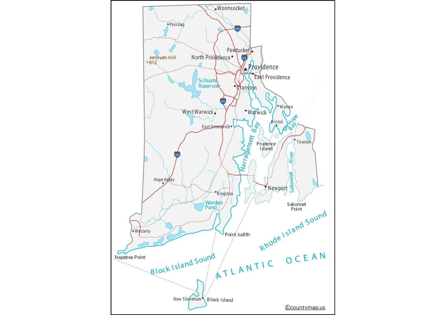
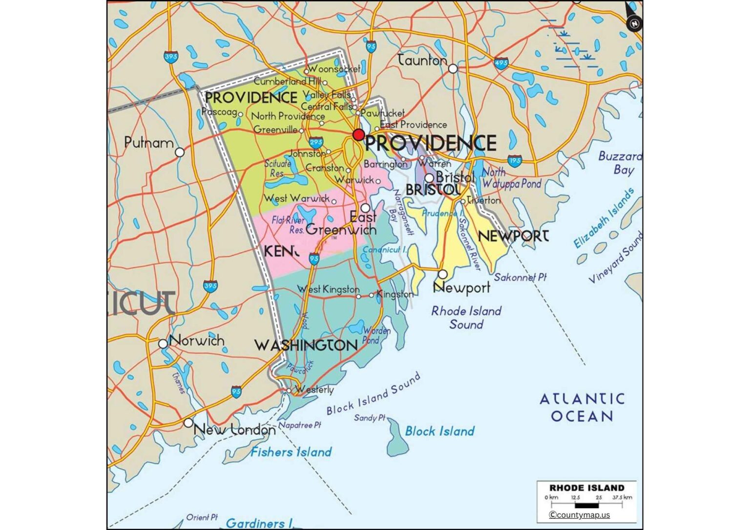
Rhode Island County Map with Cities gives a good idea about the geographical and administrative division of the state. The smallest state in the US is Rhode Island, which is subdivided into 5 counties, including Providence, Kent, Newport, Bristol, and Washington. In spite of its small size, the state is overpopulated, and the county map reveals such large cities, towns, and urban centres as Providence, Warwick, Cranston, Pawtucket, Newport, and East Providence.
The most populated county is Providence County, where the state capital, Providence, is situated, and which is an economic, cultural, and educational centre. There are also other major urban centres of this county, namely Cranston and Pawtucket. Kent County is home to Warwick and West Warwick, which a business and manufacturing hubs, and to T.F. Green Airport. The cities of Newport and Middletown are found in Newport County, a picturesque and historical place, and the cities are tourist and maritime-oriented. Bristol County also includes Bristol, a town that is famous due to the Fourth of July festivals and historical sites. The Washington County or South County encompasses Westerly and Narragansett cities, which have beaches and recreational tourism.
The population of Rhode Island and the ratio between urban and rural areas can be observed through the county map that contains cities. It demonstrates the concentration of the urban centres in the state in the northern counties, and the southern counties have small towns and recreational communities. The map can be used by urban planners, educators, tourism, and government in urban planning, education, tourism, and governance, as it gives the total picture of the cities in Rhode Island and the geographical location of the cities in the counties.
Rhode County Map with Capital
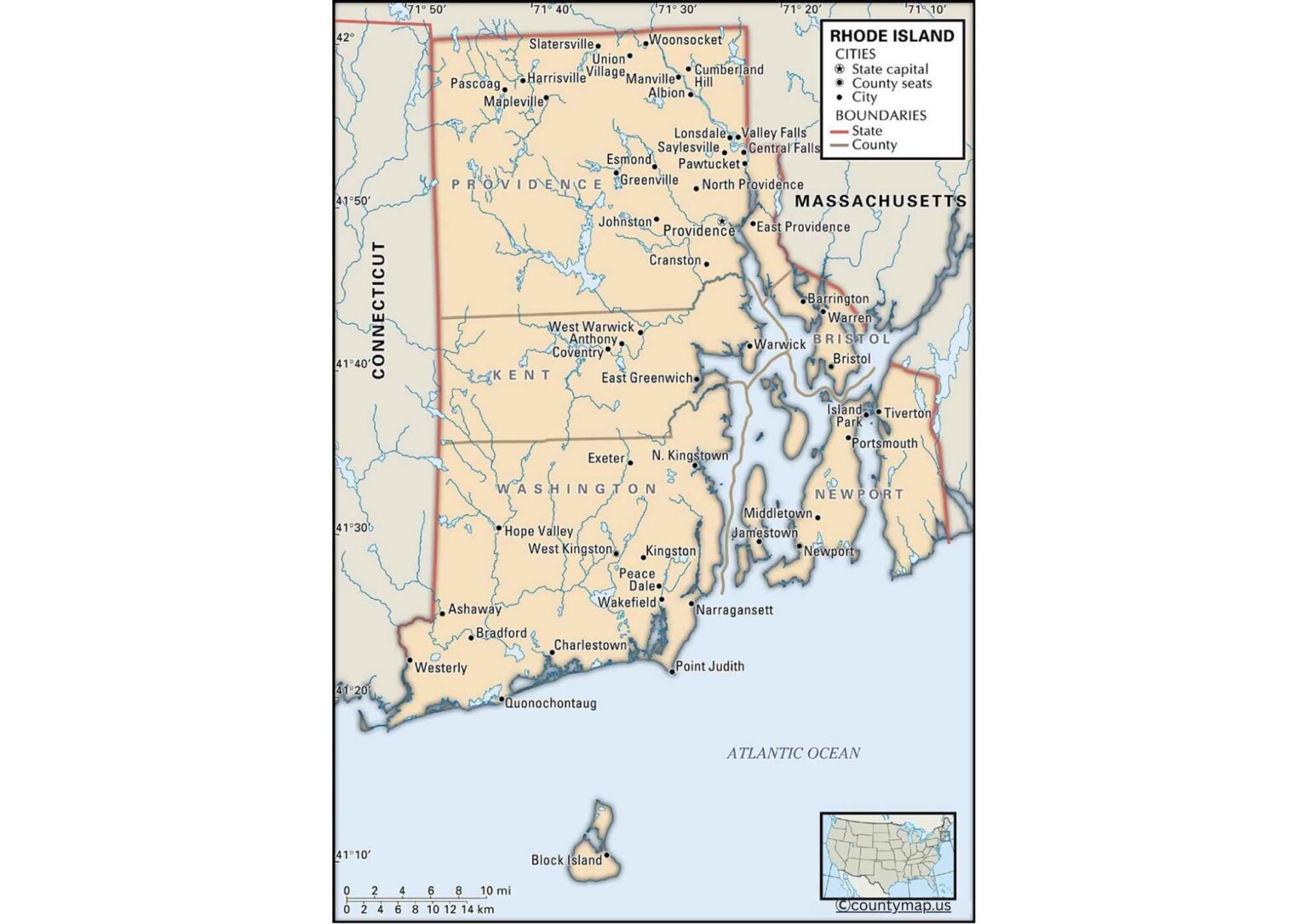
The Rhode Island County Map with Capital is focused on the state capital, Providence, which is situated in Providence County. The political centre of Rhode Island is Providence, which is the location where the state government, legislative offices, and judicial institutions are located. The map reveals that it is positioned at the north of the state and thus it is easily accessible to other cities within the vicinity, such as Cranston, Pawtucket, and East Providence.
The capital, as well as a cultural and economic centre, is Providence, which hosts Brown University and Rhode Island School of Design (RISD), hospitals, and corporate offices. As shown in the county-capital map, Providence is an area with links to the rest of the counties through highways and road networks such as Interstate 95 and 195, making it more accessible all over the state.
The map also points out the association of Providence with the other county seats, like Newport in Newport County, Bristol in Bristol County, and Westerly in Washington County. Being in the heart of the urban corridor in the North, it can affect economic, educational, and political processes in the state. The capital map also illustrates how small the state is, with all the counties being relatively close to the city of Providence, and thus, governance and delivery of public services are efficient.
The county-capital map is an important resource to the students, planners, and tourists who need to understand the governance, infrastructure, and connectivity of Rhode Island in this region. The strategic location of Providence strengthens the city in terms of acting as a centre of unity in the state, as it connects urban centres, historical sites, and cultural landmarks in all the counties.
Conclusion
The Rhode Island County Maps with Cities and Capital provide an in-depth view of the geography and government of the state. The city's map indicates major urban centres like Providence, Cranston, Newport, and Warwick, which depict population and economic distribution in five counties. The capital map shows the administrative, cultural, and economic importance of Providence, which is central to the connectivity and governance of the state. They are useful to the residents, researchers, planners, and tourists interested in the understanding of the compact but diverse landscape of the state.