Loading content...
South Carolina County Map | SC Counties with Cities
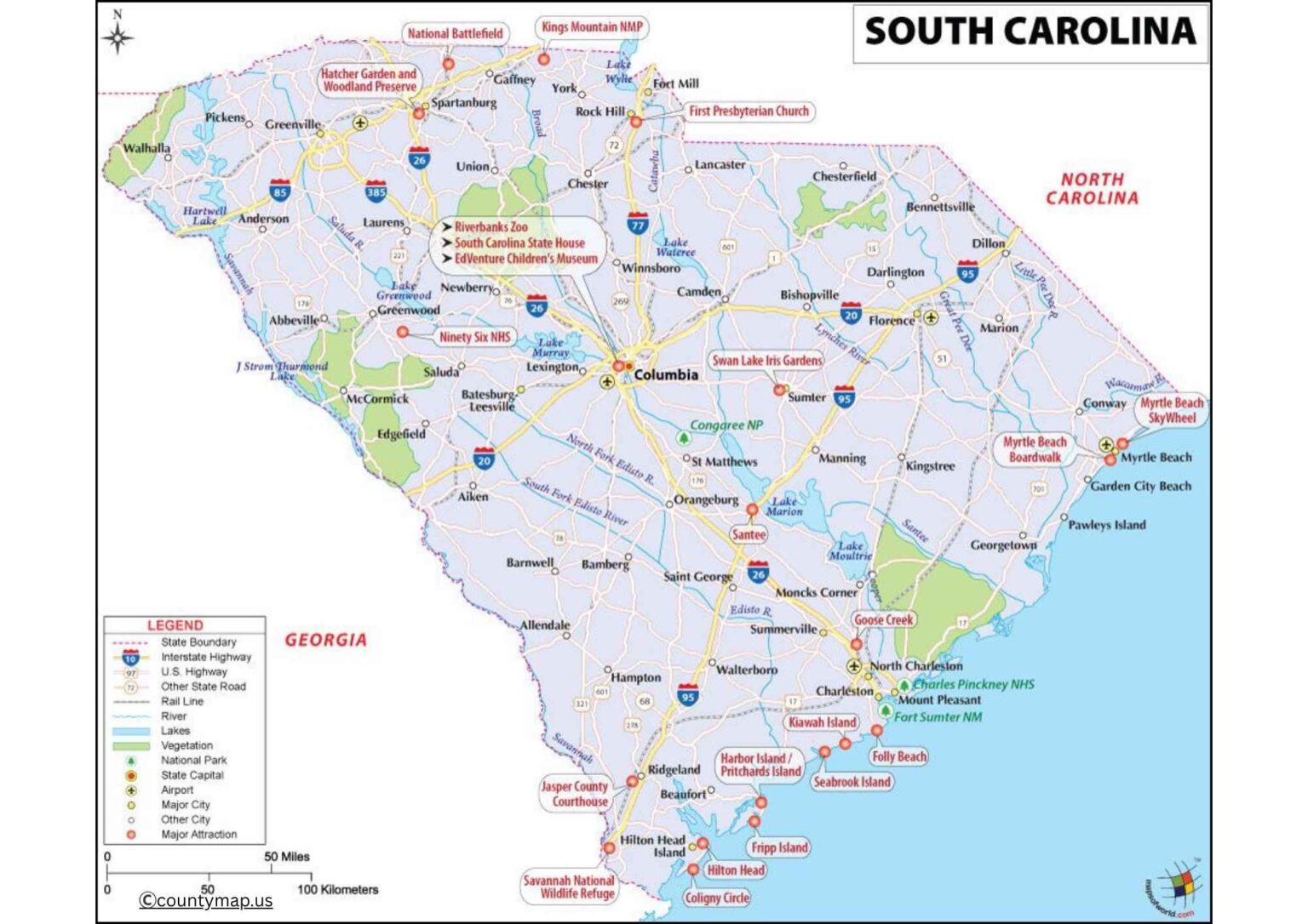
The South Carolina County Map is a detailed map that shows the 46 counties within the state, as well as their geographical structure and major attractions. South Carolina is known to have varied landscapes such as coastal plains and beaches, rolling hills and mountains, and an elaborate county map will guide one through these parts. The map would be of great importance, as it singles out major cities, towns, rivers, highways, and natural landmarks, and thus is of great importance to students, travelers, researchers, and residents.
It is a great resource in terms of planning road trips, learning the local history, examining demographic trends, and becoming familiar with economic and cultural variations at the county level. The map can be used as a valuable aid in government planning, education, and tourism by indicating county boundaries, county seats, and major transportation routes. The South Carolina County Map is easily accessible and easy to read, providing a clear view of how the state is put together and assisting users in discovering the scenic beauty and regional diversity of the state without any difficulty or inaccuracy.
South Carolina County Map with Cities
South Carolina is a state in the southeast of the United States, which consists of 46 counties, each with different geographic, economic, and cultural features. The largest county area-wise is Charleston County, whereas the most populous is Greenville County. Such big cities are Charleston, Greenville, Columbia, Spartanburg, and Myrtle Beach, all of which are economic and cultural hubs. Charleston, Charleston County, has a history of architectural buildings and port facilities, whereas Greenville (Greenville County) boasts of manufacturing, technology, and commerce. The state capital, Columbia, is found in Richland County and serves as a seat of government, education, and culture.
Others that have achieved fame are Horry County, which contains the renowned beaches of Myrtle Beach, and Richland County, where urban growth is merged with rivers and natural parks. The county map of South Carolina also puts focus on the natural features like the Blue Ridge Mountains in the northwest, the Piedmont region in the center, and the Atlantic coastline in the east. The rural counties, such as McCormick and Williamsburg, specialize in agriculture, forestry, and small towns, whereas the urban counties have a variety of industries, which include finance and healthcare, tourism, and manufacturing.
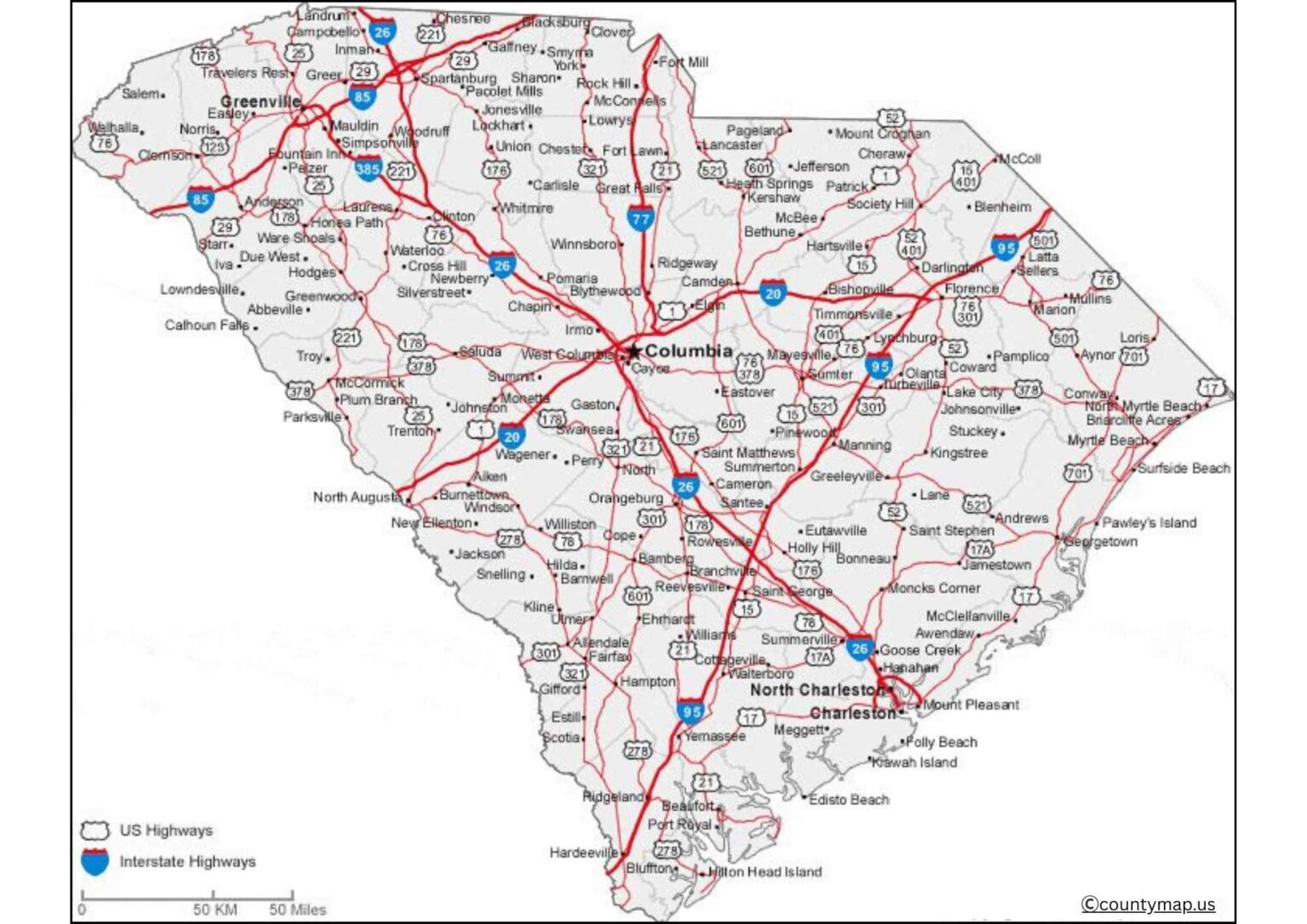
The map highlights the location of large cities by counties and highlights transportation, such as interstate highways, railroads, and major rivers, that connect urban and rural areas. Knowing the county map of South Carolina and its cities is imperative in identifying the demographic trends, economic centers, and cultural landscapes and planning travels, commerce, and regional development.
South Carolina County Map with Capital
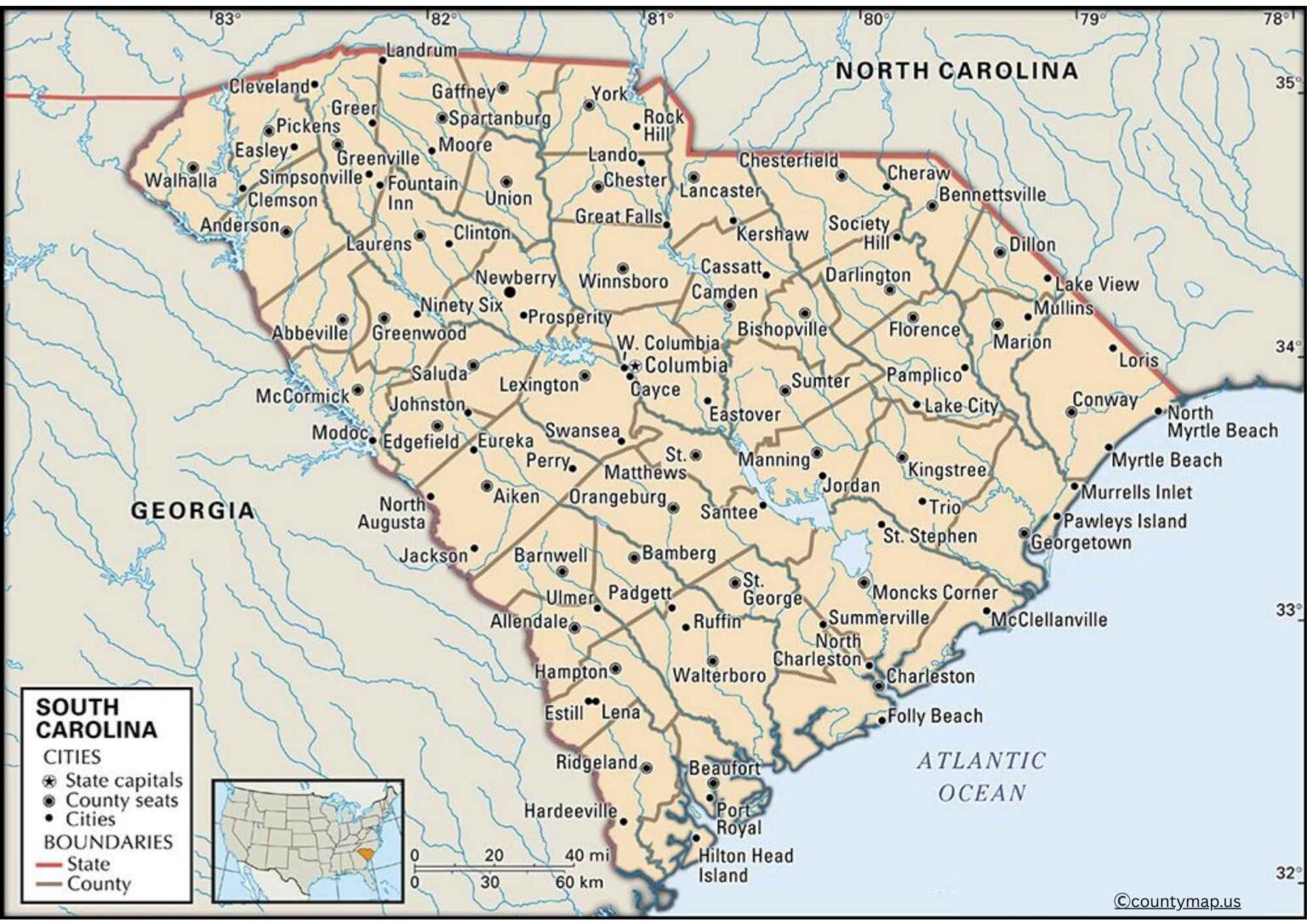
Columbia is the capital of the state, and the map of the South Carolina county shows it in Richland County, close to the geographic center of the state. The city of Columbia is in the middle of the country, and thus, it is accessible by almost all regions, making it the administrative and political center. The State Capitol and government offices, as well as significant education facilities (University of South Carolina), are found in the city. The fact that it is situated on the Congaree River has traditionally facilitated trade, transportation, and regional growth.
Columbia is located in the county, which is called Richland County, and is bordered by such counties as Lexington, Kershaw, Sumter, and Calhoun. The county map insists on the relationship of Columbia with other counties through major highways such as I-26, I-20, and I-77, which allowed the county to conduct commerce, transportation, and communication within the state. Columbia is also a cultural and economic hub that hosts large sports facilities, arts centers, and business centers that bring people to the county.
This county map of South Carolina, including the capital, portrays how Columbia fits in the urban and rural areas of the state, tying the economic actions of Greenville, Charleston, and Myrtle Beach to the state government action. Though the cities of the coast and upstate dominate in terms of business and tourism, Columbia maintains a centralized administration, educational leadership, and area coordination. Rivers, county lines, and infrastructure are also marked on this map, showing how the city is strategically important in connecting the entire state of South Carolina.
Conclusion
The county maps of a state such as South Carolina show that the green buildings are a combination of urban centers, rural communities, and natural scenery. The economic and cultural centers of the counties, such as Greenville, Charleston, and Horry, are present, whereas the capital of the state is located in Richland County. The maps demonstrate the distribution of population, transportation systems, and connectivity between regions, where the interactions of governance, trade, and culture can be seen. The knowledge of these maps will help see the demographic trend in economic activities and past historical sites, as these urban and rural regions have a collective experience in shaping the state's character, growth, and strategic value.