Loading content...
Virginia County Map | VA Counties with Cities

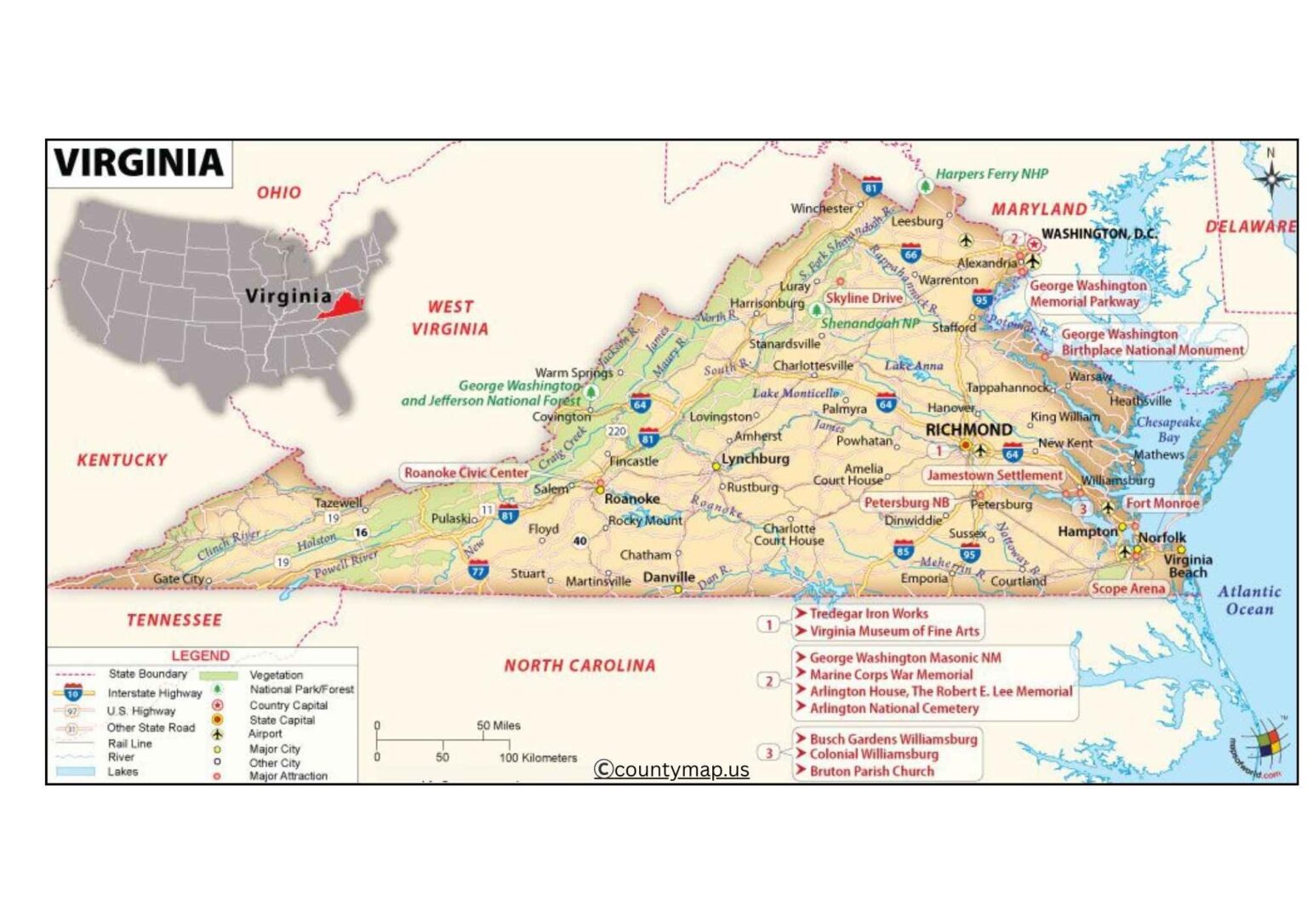
The Virginia County Map provides a complete display of the 95 counties and independent cities of the state so that users understand the geographic structure of Virginia and the administrative divisions within the Commonwealth. It is a valuable resource for students, travelers, researchers, and anyone who wants to understand Virginia. The map provides county boundaries and county seats and shows major roads for easy navigation and exploration. Virginia is diverse and shares landscapes ranging from the Atlantic coastline to the Blue Ridge Mountains and the Piedmont region.
The map allows users to plan trips study population demographics explore historical patterns, and understand the components that make each county unique Users can explore urban settings rich in history and picturesque landscapes that are more rural and natural. The combined versatility of the Virginia County Map can offer valuable information for education, trip planning, and overall geographic knowledge The map brings together accurate information and simple use so that referencing the content becomes easy and strengthens user knowledge of the structure and regions of the Commonwealth of Virginia.
Virginia County Map with Cities
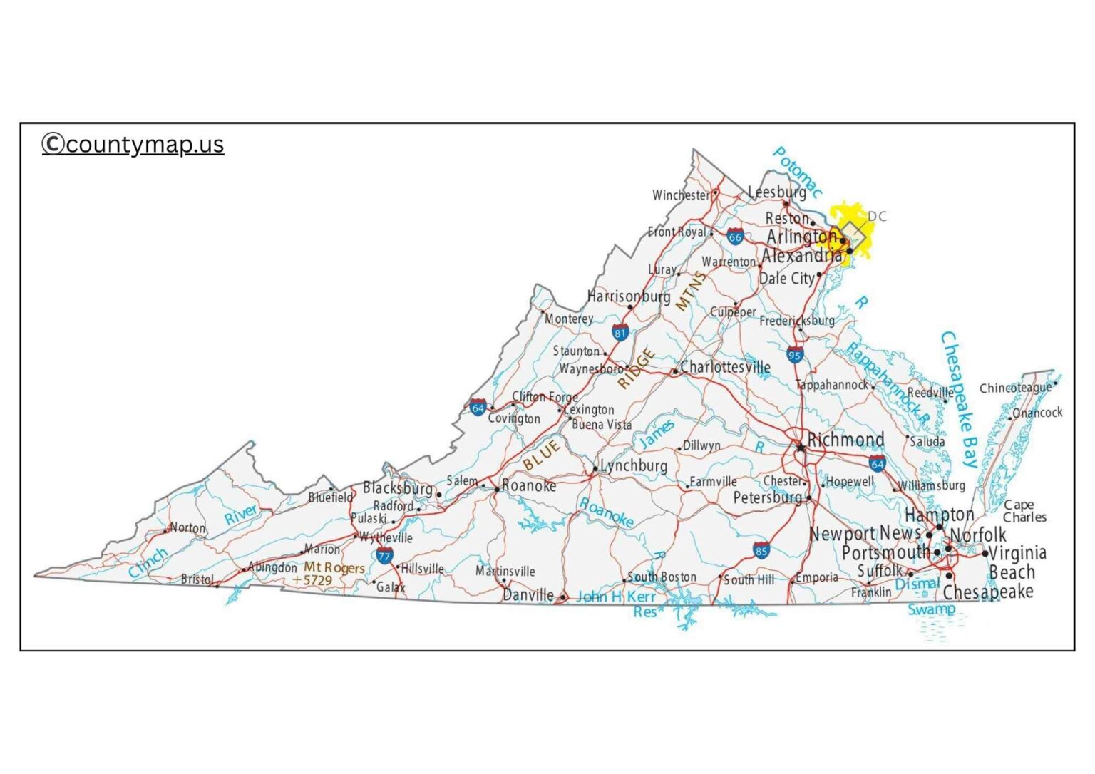
The Virginia County Map with Cities allows one to have an adequate glimpse at the distribution of the urban centers in the state, with its 95 counties and 38 independent cities. The state of Virginia, in the Mid-Atlantic and Southeastern regions of the United States, has a system of independent cities, thus lacking counties; thereby, it has a different administrative structure. Big cities are Virginia Beach, Norfolk, Chesapeake, Richmond, Newport News, Alexandria, and Roanoke, and they make the state a diverse environment in terms of economy and culture.
The Hampton Roads cities of Virginia Beach, Norfolk, Chesapeake, and Newport News are indicated in the eastern Tidewater region of the map. This is among the biggest metropolitan areas of Virginia, which is also involved in shipbuilding, naval bases, tourism, and coastal trade. To the inland areas, Richmond, the city in Henrico and Chesterfield counties, is a significant financial, cultural, and historical city. Northern Virginia is a section of the Washington, D.C., metropolitan region, and it encompasses the cities of Alexandria, Arlington (a county), and Fairfax, which are the locations of technology, defense, and government contracting.
Cities like Roanoke, Lynchburg, Charlottesville, and Harrisonburg are educational, agricultural, and industrial hubs in the west and central regions of the state. Smaller historic towns that are of importance in the history of colonial and Civil War days in Virginia can also be identified in the county map with the cities, and they include Williamsburg and Fredericksburg.
The map is very helpful in learning the layout of the counties and towns of Virginia as they traverse mountains, valleys, coastland, plains, and the urban corridors. It gives an insight into the distribution of the population, economic regions, and cultural landmarks, making it a valuable resource in the hands of educators, planners, travelers, and researchers.
Virginia County Map with Capital
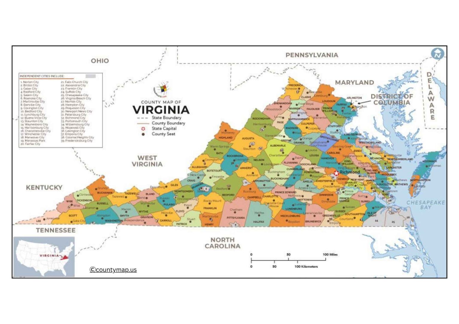
The Virginia County Map with Capital concentrates on the state capital of Richmond, which is situated in the middle of the state, on the James River. Richmond is also an autonomous city that is located in the counties of Henrico and Chesterfield, which is also characteristic of the system of administration in Virginia. According to the capital map, it is clear that Richmond is at the center of the location, and, therefore, it is an accessible hub in governance, commerce, and transportation.
Richmond has the Virginia State Capitol, the Governor's Mansion, the General Assembly, and many other government offices, making the politeness of the place hard to ignore. The map indicates that highways like I-95, I-64, and U.S. Routes allow Richmond to be linked to other major areas such as Northern Virginia, Hampton Roads, and western counties. This would be a strategic point of positioning Richmond as a central meeting point between urban and rural societies.
The metropolitan area of Richmond comprises the counties of Henrico, Chesterfield, and Hanover, which are also important in terms of sustaining the metropolitan expansion of the city. The county map shows how the county is placed in terms of proximity to neighboring cities like Petersburg, Williamsburg, and Charlottesville, which are not only historically and educationally significant. It also gives emphasis to the fact that Richmond is very close to the capital of Washington, D.C., which reaffirms its position as a component of the political and economic Mid-Atlantic region.
The map highlights the historical significance of Richmond since 1780, when it became the capital selected to replace Williamsburg as the capital city due to greater security during the Revolutionary War. Richmond is a city today that is mixed with both a government and a flourishing economy on the basis of finance, law, healthcare, and manufacturing. The capital map is an excellent tool for learning and planning, revealing the importance of the central role of Richmond in the governance and development of the whole state.
Conclusion
The combination of the Virginia County Maps and the Cities and Capitals gives a close-up view of the distinct geography and government of the state. Urban centers that are marked in the city map include urban hubs like Virginia Beach, Norfolk, and Alexandria, and historic towns and independent cities that are located in 95 counties. The capital map focuses on the core location of the city of Richmond in terms of politics, culture, and transportation, highlighting the impact it has on other counties and regions. These maps combined demonstrate the wide array of economy, history, and government of Virginia. These are crucial to students, tourists, and planners who desire to know how the state is urbanized and politically arranged.