Loading content...
West Virginia County Map | WV Counties with Cities
The West Virginia County Map is a comprehensive map of the 55 counties in the Mountain State, which is why the map is a must-have guide for travellers, students, and researchers. West Virginia is a state that is based on its history and good nature because of the rugged mountains, scenic rivers, and a rich cultural heritage. Using this county map, a user can find boundaries, identify the county seat, and know what kind of geographic structure creates the unique character of the state.
West Virginia County Map with Cities

The map is a good resource to rely on, whether on a road trip or doing research on regional demographics, as well as historical and geographical research. Every county is unique, from the coal mining heritage of the south to the spectacular scenery of the Appalachians in the east. The West Virginia County Map is used not only to focus on the administrative divisions but also to explore the attractions, plan local travels, and learn more about various communities in the state.
The map of West Virginia counties contains the cities, giving a valuable perspective of the state's administrative divisions and cities. West Virginia is subdivided into 55 counties with cities, towns, and other smaller communities. These maps are useful in terms of their ability to provide an insight into the population distribution, economic centers, and routes in and around the state.
The biggest cities are Charleston (Kanawha County), Huntington (Cabell County), Morgantown (Monongalia County), Parkersburg (Wood County), and Wheeling (Ohio County). The largest city in the state, Charleston, is a commercial and cultural center with its industries and historic sites. Huntington, home to Marshall University, is an educational and industrial hub, and Morgantown is the host to West Virginia University, making it an active college town.
Printable West Virginia County Map with Roads

Other important cities such as Martinsburg (Berkeley County), Clarksburg (Harrison County), and Fairmont (Marion County) have a role to play in the economy of the state through manufacturing, health care, and services. The geography and distribution of settlements are depicted through a county map with cities that can be used to see how the urban centers are spread both along the Appalachian Mountains and the Ohio River Valley.
The fact that both the counties and the cities are highlighted makes these maps a very effective tool for students, travelers, researchers, and policymakers. They give a clue into the regional variations, including the industrial towns of the north and rural and mountainous settlements to the southeast. An in-depth map allows more planning, navigation, and knowledge of the social, economic, and cultural landscape of West Virginia.
A map of West Virginia counties highlights the capital of each county, which is the center of administration and government. Every county of the 55 counties has a certain seat, which usually comprises the courthouses, the local government offices, and the community services.
Charleston (Kanawha County) is the capital of the state and also the political and economic center. It is home to the office of the governor, the state legislature, and the offices of many administrative bodies. Charleston is the capital of the state as well as a cultural and business hub.
Free West Virginia County Map with Capital
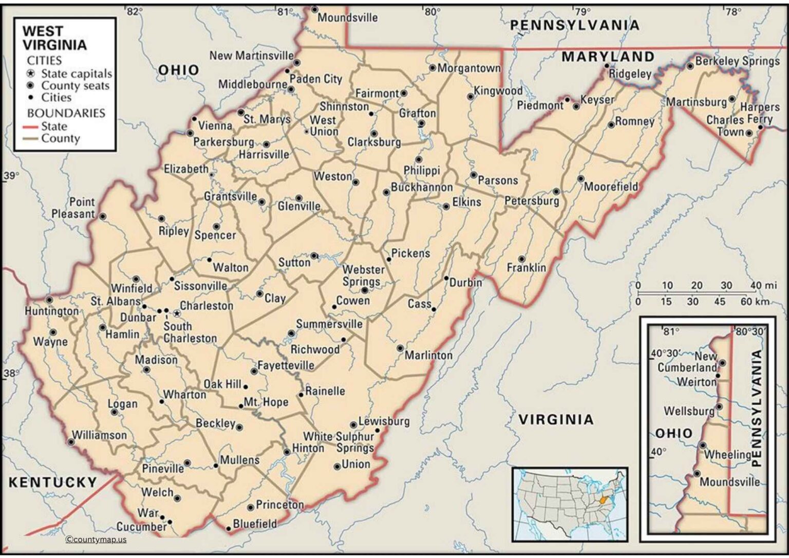
Other major counties include Huntington (Cabell County), Morgantown (Monongalia County), Parkersburg (Wood County), and Wheeling (Ohio County). Such seats are critical to local government and offer vital amenities to the neighboring communities and towns. Smaller county seats like Elkins (Randolph County), Lewisburg (Greenbrier County), and Beckley (Raleigh County) are also of significant importance in the process of upholding local government and community organization.
A county map with capitals will enable the residents, researchers, and policymakers to perceive the administrative setup of West Virginia. Emphasizes the role of urban centers and small towns in acting as agents of government, linking people in mountainous and river valley areas. Such maps cannot be planned without them, as they are useful in legal aspects, as well as the knowledge of how the services are organized at the county level.
Conclusion
The county maps of West Virginia with cities and capitals give supplementary views of the state. Maps of cities emphasize economic, educational, and cultural centers, whereas those with the county seats accentuate governance and administration. The combination of them indicates the interaction of the population center, the local services, and the mountainous landscape, which defines the settlement patterns. These maps play an important role in the education, travelling, research, and planning of the state, providing a clear overview of the social picture of the state and the administrative system. They put together geographic and administrative data and thus make it simpler to traverse, comprehend, and admire diverse regions of the state.